An Exploration of Hartburn, Warkworth & Woodhorn
By Crasterfarian
Across Northumberland’s rivers and roads, clues linger, carved in stone, hidden in caves, worn into the bedrock. They whisper of a time before churches, when Roman soldiers worshipped in shadowy shrines and sacred rivers carried not just fish and silt, but the blood of sacrificed bulls.
This is the story of three sites: Hartburn, Warkworth and Woodhorn, bound by ancient roads, sacred water and a sense that something older lies just beneath the surface. Nothing sinister, but different and it was this difference that made them vulnerable to destruction.
These places all had a pagan past that was overwritten but never quite erased. These areas feel different. It’s not the inclement Northumbrian weather, it’s much deeper, almost ethereal: a sense of something separate from the norm.
Hartburn Glebe: A Cave with Secrets

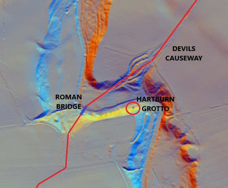
At Hartburn, Northumberland, the Devil’s Causeway reaches the river gorge of the Hart Burn, a tributary of the River Wansbeck.
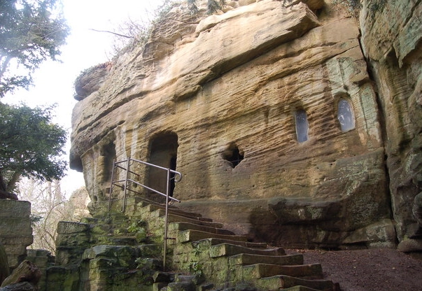
In the LiDAR image you can see where countless centuries of carts, horses and people have worn their way up the north east side creating what looks like rivulets on the banksides. As the road negotiates down the south west side of the bank to meet the Roman bridge, there is a small cave right beside the river.
This cave was supposedly modified in the 18th century by Dr. Sharpe into a changing room for ladies bathing in the burn to preserve their modesty.
As with many Christian sites, above its entrance are two carved niches, once holding statues of Adam and Eve. (these niches can be seen in the first picture).
As we already know, nearby lie the stone sockets of a Roman bridge, cut into the riverbed.
The cave itself is just the kind of spot Roman soldiers would have chosen for a mithraeum, a cave-temple to Mithras, god of light and oath. In Mithraic tradition, two figures, Cautes and Cautopetes, the torchbearers of dawn and dusk always flanked the entrance to the temples. The ones that flanked the mithraeum at Brocolitia are on show at the Great North Museum.
The niches at Hartburn Grotto will also have held them, long before Christian statues were installed. I’d love to think that somewhere down stream in the river, they lie waiting to be discovered. Although it’s more likely that the existing statues of Cautes and Cautopetes were remodelled into Adam and Eve and popped back in their place.
Warkworth: Fort, Port, and Forgotten Shrine?
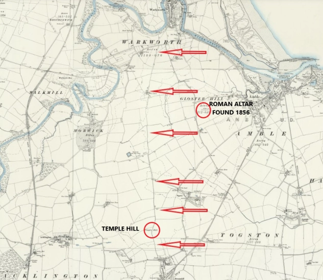
As shown above, I have postulated a Roman road that headed north to link Woodhorn and Warkworth in Roman times.
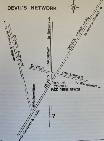
The late great Raymond Selkirk talked of a ‘Devils Corner’, a junction on the Devils Causeway south west of Longhorsely where the road took a strange turn. He believed that at this point, roads forked off in several direction and one, headed to Woodhorn, a site he was convinced was Roman.
Following that old route north from Woodhorn to Warkworth, a Roman road appears to run through the landscape, connecting the two sites. As the modern road turns a sharp right to head down past Togston and Amble, the ancient route disappears under a terrace of houses, then, just north of Broom Hill, it passes an intriguing spot called Temple Hill, the name alone hinting at a lost place of reverence.
Was there a temple here? A Roman staging point where travellers, legionaries and pilgrims have stopped for centuries to water their horses and replenish their souls at the shrines.
In 1856 a Roman altar fragment was found not far from Temple Hill in a field called Wallington Green approximately 800 metres west of Amble. Its discovery suggests Roman activity in the wider area.
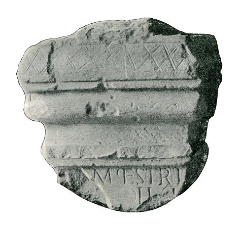
Its partial inscription reads:
“MATRIBUS CAMPESTRIBUS COHORS PRIMA”
To the mother-goddesses of the parade-ground, by the First Cohort
*This links it to cavalry training activities
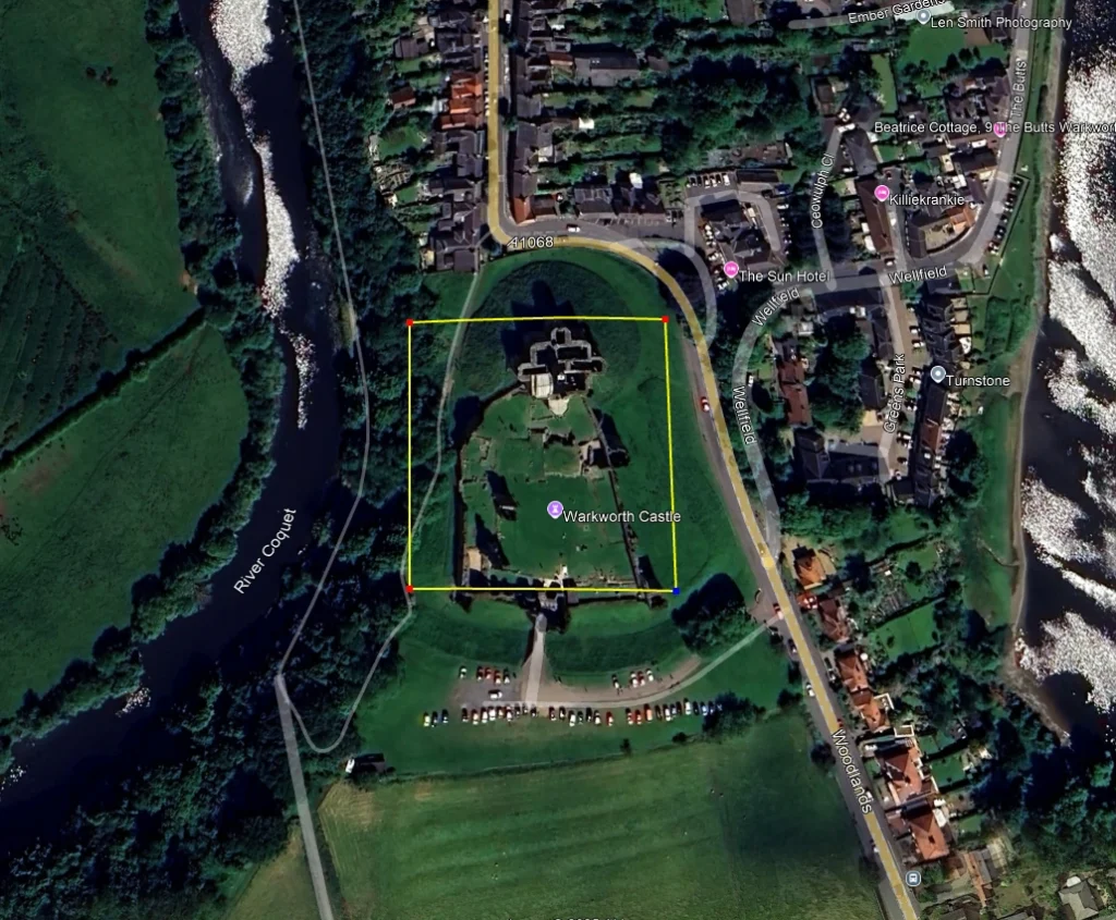
My question is, what lies beneath Warkworth Castle itself, an ancient stronghold guarding the isthmus of the loop in the river Coquet?
The village itself is ancient. It is first recorded in 737 AD when King Ceolwulf of Northumbria gave the church and village to the Abbot and monks of Lindisfarne, meaning the village had already been in existence for some time for this to happen.
This stunning loop in the Coquet has always been an easily defensible site, a fact that won’t have been lost on the legions as they pushed further north to tame the land. Did the legionary architects and planners build a fort under the site of the Castle? Has the meandering western side of the loop consumed, through the layers of time, the edge of the fort?
I’ve laid this square out at 100m x 100m which would be small for a fort but there are forts of that size elsewhere within the Empire, and Northumberland.
The Port at Warkworth
The Coquet’s broad mouth at Amble, sheltered by its island, would provide a safe entrance to the river, as it does to this day. It’s easy to imagine a small Roman port at Warkworth safely in-land protecting Roman shipping from the ferocious storms that the North Sea produces. Incidentally the harbour at Amble is called ‘Warkworth Harbour’.
The Hermitage
Carved into the rock across the river to the west is the famous Hermitage, a medieval chapel built into the sandstone. Its altar, cave layout and even the carving of a nativity scene featuring a bull’s head echo earlier Mithraic symbolism. Was this, too, once a mithraeum, later rebranded as Christian?
Woodhorn: The Sacred Starting Point
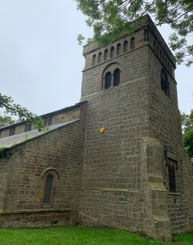
To the south lies Woodhorn, where the Church of St Mary the Virgin rises over what may have been an older temple site. Though now Christian, the land itself bears signs of a deeper past, ancient roads converge here, including links to the Devil’s Causeway.
Woodhorn’s position suggests it may have been a religious complex long before the Saxon church was built. Perhaps it was cleansed and rededicated like the others.
Look at the stonework in the lower, oldest part of the tower. It is distinctly Roman.
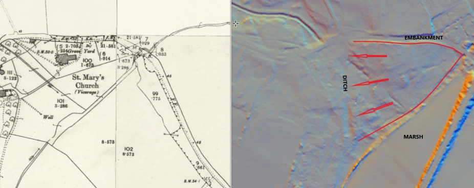
The site also stands on a narrow spit of land that may have been surrounded by marsh in antiquity. As seen here in the LiDAR, you can see the point of land and the marshy ground to the south and what could have been a bank to the north.
There is, what I believe to be a ditch running across the isthmus creating a secure site for religious activities. Was this also a mithraic site? Not a cave-based one but one built of stone, like at Brocolitia Roman Fort (Carrawburgh) on Hadrian’s Wall?
The Thread That Binds
The old roads, the Devil’s Causeway, and the track between Woodhorn and Warkworth weren’t just about marching troops or trade.
They carried belief and they linked temples.
Then later, Christianity followed the same path, placing its own symbols over the old ones, often in the same places, attempting to erase the paganism from the land and purging the old gods in place of their own One True God.
The cave at Hartburn, the cave at Warkworth, the church at Woodhorn, all may be part of a forgotten spiritual link, with Temple Hill as its forgotten milepost.
These were not chance sites. They were chosen, reused and remembered, even as their stories were rewritten.
A Holy Trinity of Reuse
Taken together, these three sites form a holy trinity of re-dedication — pagan shrines transformed into Christian sanctuaries, and eventually heritage curiosities.
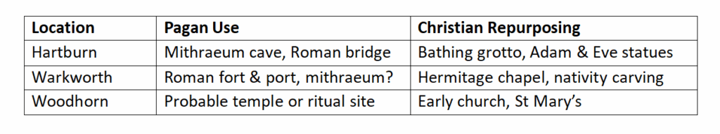
They all share the same pattern:
- Water
- Stone
- Strategic roads
- Sanctity repurposed
Written with Love from the Crasterfarian XX, for those who listen to the land, care to dream, and still hear the echo of old gods under their boots.