How likely is it that significant Roman aftefacts and structures were cleared when the shipyard was expanded at the turn of the 20th century?
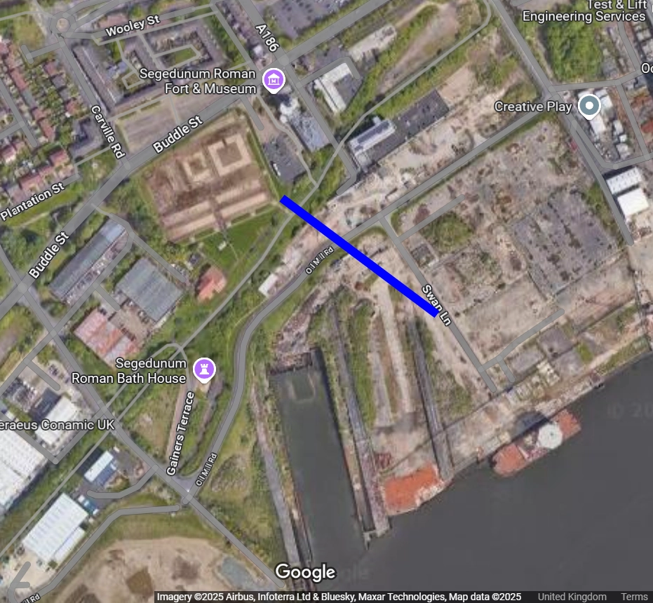
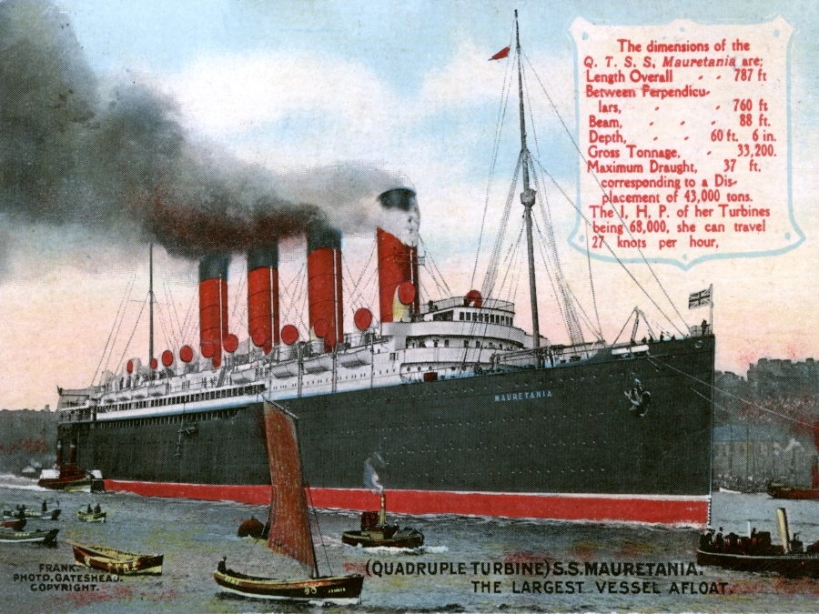
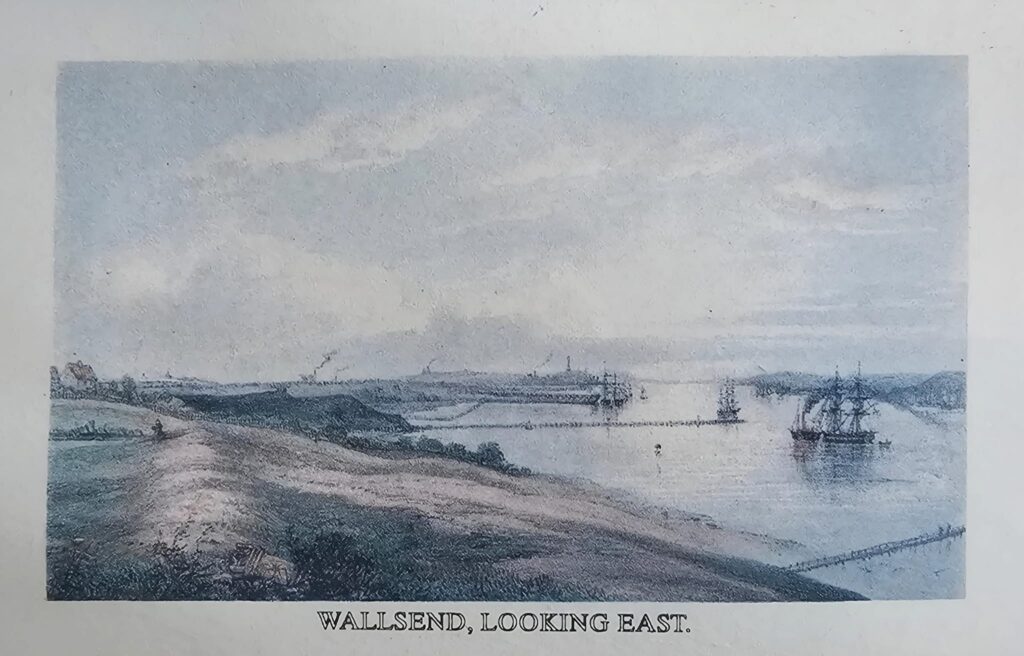
Hundreds of ships were built at Swan Hunter during its lifetime, from ferries, to state-of the-art warships, to iconic supertankers. But the first really big ship was the one and only Mauretania, ‘Queen of the Tyne’. Mauretania was started in 1903 and launched in 1906 and it was for this enormous undertaking that the main slipway at Swans was built. Today it still stretches over the riverside landscape below Segedunum.
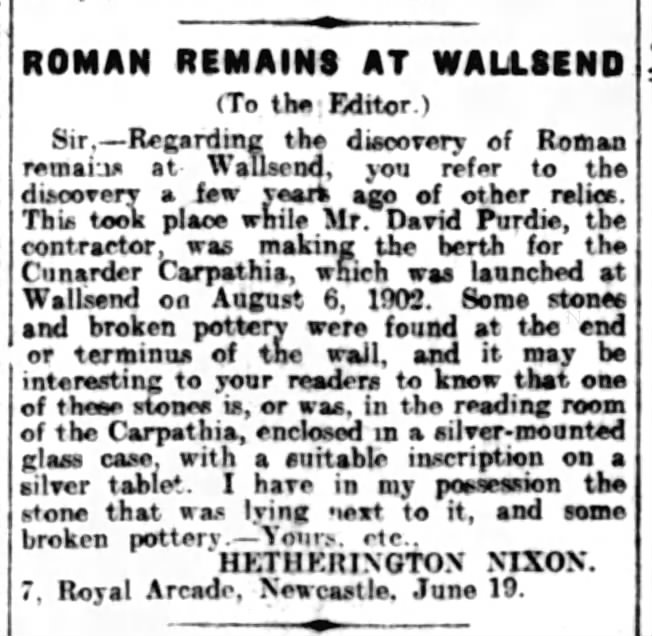
It was during this work that the main span of the Roman branch wall was discovered and presumably mostly broken up. A small section of the wall was removed to Richardson Dees Park before being returned to the top of the site in the 1990s, but this doesn’t account for the rest of it.
We have to understand the context of all this. The 1900s were the golden age of shipping. Local men built enormous vessels of outstanding beauty and fitted them with the highest level of craftsmanship, while the contracts that flowed from this industry provided for a large chunk of the Tyneside population. But the pressure to forge ahead meant that some Roman remains have been lost to us today, either buried beneath the concrete or cleared away and washed out by the river.
An Older Empire
Segedunum was a critical hub for the Roman military. The fort would have had a dock with warehouses and it is speculated that a temple to Hadrian stood at the terminus of this branch wall, which led out possibly as far as one third of a Roman mile into what was then a shallower and wider Tyne.
There was also a village connected to the south west corner that was perhaps half a mile in breadth and that for three hundred years was a thriving place of commercial activity. We know from the description written by John Horsley, that Roman streets and workshops were still visibile in the 18th century and that as late as the 1730s children would climb on the branch wall in order to dive into the river.
Yet when the civilian settlement was excavated in the 1990s, nothing was found, likely owing to how intensively the land has been worked. However, the Historic Environment Record states this about the space:
“Over the years there have been from this area many random finds of coins, metalwork, querns, animal bones and Roman pottery, including a large part of a samian bowl (HER no. 811-829). Defensive ditches and a possible earth bank formed the western boundary of the vicus some 65 metres from the fort and the Branch Wall from fort to Tyne formed the eastern boundary. Excavations in advance of a new dry dock at Swan Hunter’s Shipyard in 2002, revealed a sequence of banks and ditches 75 metres south of the fort, forming elements of a defensive cordon most probably defining the south side of the vicus. These lay parallel to the Roman riverbank, some 160 metres north of the modern highwater mark.”
https://sitelines.newcastle.gov.uk/SMR/806?utm_source=chatgpt.com
Lost Treasure
Much is now lost and gone, though this is the fate of much of the Roman archaeological record generally. Just take a look though the bible that is Roman Inscriptions of Britain to see how many items that have been found over recent centuries are officially ‘lost’.
It’s not that the Victorians who built Swans and the Edwardians who expanded it didn’t care about history, but that the pressures of getting the work to build these groundbreaking vessels was paramount in their minds. Archaeological preservation or keeping records of finds was just not a concern at the time. Everyone was relying on the shipyard being a success. Everyone had their hopes and welfare tied up in it.
But just imagine witnessing the first work to build the slipway in 1903. It must have been like one massive uncontrolled archaeological dig, with all sorts of objects being pulled from the mud. Somewhere down there may even be the statue of Hadrian…
The same industrial fate may have erased a possible Roman harbour at Point Pleasant, as written about here. This riverbank bluff was occupied by the Wallsend Slipway and Engineering company. They were the licensee for the Parsons turbines that enabled the likes of Mauretania to hold the Blue Riband for a record 20 years and for Carpathia to rescue 705 survivors just two hours after the Titanic had sunk.
The Neptune Yard too, just up river from Swans, has in what could be described as a minor miracle, been uncovered as the site of extremely rare pre-industrial timber rail tracks which formed the end of the Willington Waggonway and which were found during development works by Shepherd Offshore.
We can only wonder what further historic finds lie buried beneath the mud, concrete and the riverbed at Wallsend…
Addendum
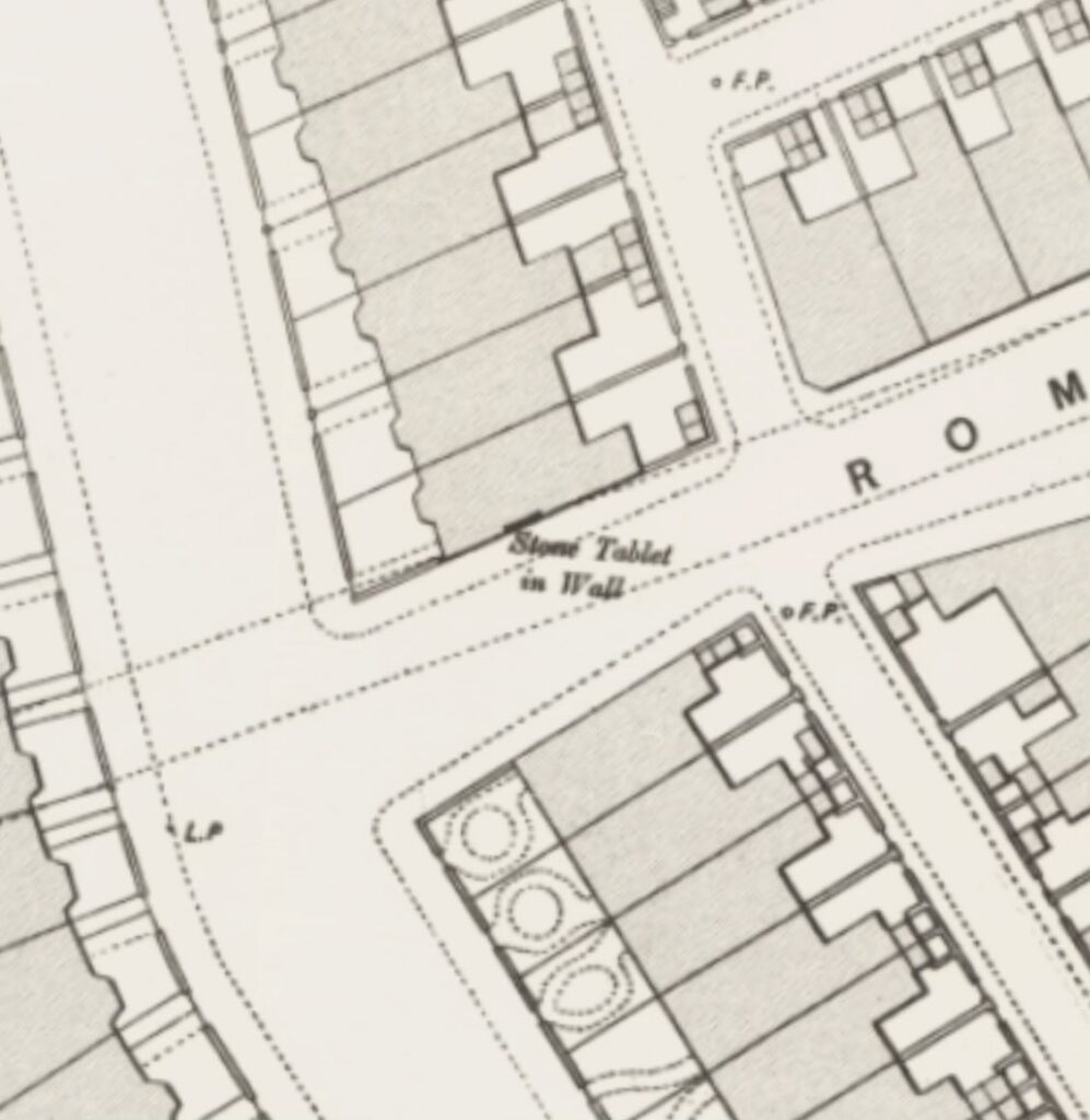
https://maps.nls.uk/geo/explore/#zoom=19.4&lat=54.98671&lon=-1.53787&layers=117746211a&b=MapTilerStr&o=100
via NE Heritage Library on X. This may be a centurial stone.
Update 1:
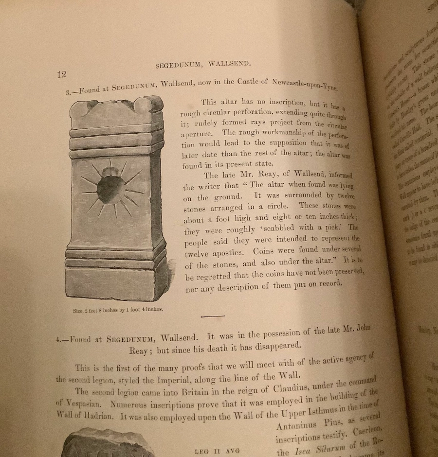
Wallsend vicus, Roman altar from ?temple
https://sitelines.newcastle.gov.uk/SMR/814
“In 1851 Bruce recorded and illustrated an altar found a few years earlier south of the south-west corner of the fort. “When discovered it was lying on the ground surrounded by a ring of twelve stones. Each stone was about one foot high and eight or ten inches broad; all twelve stones were roughly dressed. Coins were found under the altar and under several of the stones…”. It is thought to denote the existence of a temple. The altar is uninscribed, 2 feet 8 inches x 1 foot 4 inches. It “is pierced by a circular hole, 6 inches in diameter, through the centre of the die…The opening is surrounded by twelve incised lines radiating from this central hole, and the design is perhaps meant for a rayed sun. The hole would allow a ray of light to pass through if inclined at not more than 45 degrees to the axis of the hole, and the altar could have been used in connection with sunrise and sunset”.”
Update 2:
Via Dave Parish on X:
Never miss an article. Enter your email or give our FB page a like
No air-built castles, and no fairy bowers,
But thou, fair Tynemouth, and thy well-known towers,
Now bid th’ historic muse explore the maze
Of long past years, and tales of other days.
Pride of Northumbria!—from thy crowded port,
Where Europe’s brave commercial sons resort,
Her boasted mines send forth their sable stores,
To buy the varied wealth of distant shores.
Here the tall lighthouse, bold in spiral height,
Glads with its welcome beam the seaman’s sight.
Here, too, the firm redoubt, the rampart’s length,
The death-fraught cannon, and the bastion’s strength,
Hang frowning o’er the briny deep below,
To guard the coast against th’ invading foe.
Here health salubrious spreads her balmy wings,
And woos the sufferer to her saline springs;
And, here the antiquarian strays around
The ruin’d abbey, and its sacred ground.
Jane Harvey
From ‘The Castle of Tynemouth. A Tale’ (1806)
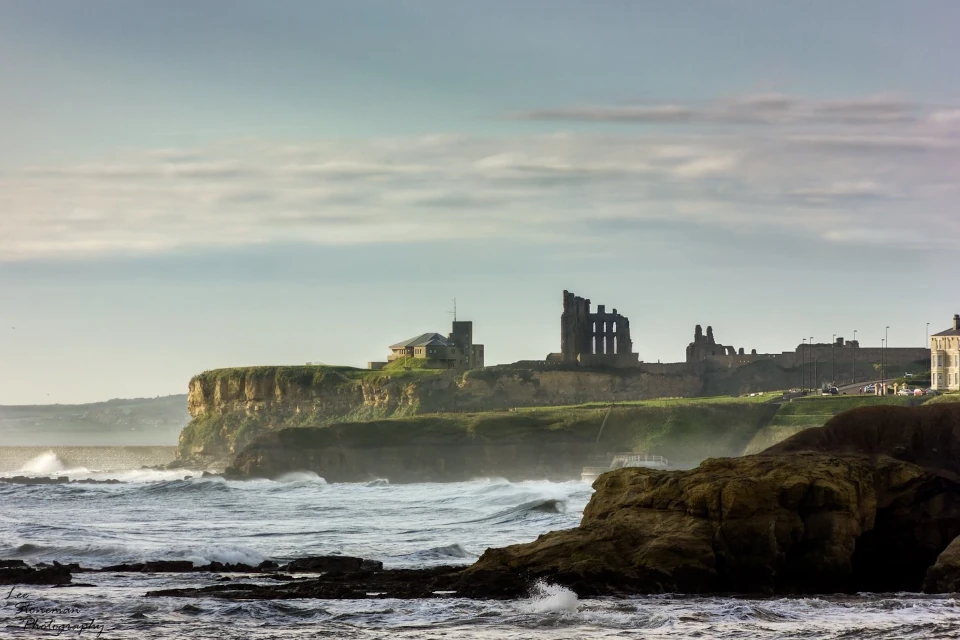
Photograph: Lee Stoneman
Photograph: Lee Stoneman
No air-built castles, and no fairy bowers,
But thou, fair Tynemouth, and thy well-known towers,
Now bid th’ historic muse explore the maze
Of long past years, and tales of other days.
Pride of Northumbria!—from thy crowded port,
Where Europe’s brave commercial sons resort,
Her boasted mines send forth their sable stores,
To buy the varied wealth of distant shores.
Here the tall lighthouse, bold in spiral height,
Glads with its welcome beam the seaman’s sight.
Here, too, the firm redoubt, the rampart’s length,
The death-fraught cannon, and the bastion’s strength,
Hang frowning o’er the briny deep below,
To guard the coast against th’ invading foe.
Here health salubrious spreads her balmy wings,
And woos the sufferer to her saline springs;
And, here the antiquarian strays around
The ruin’d abbey, and its sacred ground.
Jane Harvey
From ‘The Castle of Tynemouth. A Tale’ (1806)
In 300 years, generations lived and worked in similar areas to the sites that hosted our industrial revolution. The best recorded sites are in rural areas, while are least recorded sites lie below more recent generations of toil. We hope to fluke more lucky breaks, like Wallsend.
Good point!