By Gary Holland and Luan Hanratty
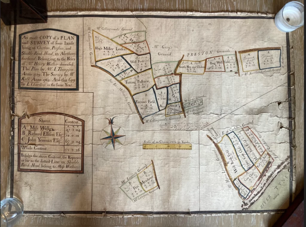
The image above shows a plan of land ownership of the North Shields area in the 1700s. This fascinating document dates from 1768 and is one of the earliest plans of the area that we have.
What is also interesting about this plan is that it is dated five years prior to the Enclosures Act of 1773. Thus this map catches the last vestiges of agriculture involving people tending to small scattered sections of land.
The Enclosures Act of 1773 was a pivotal piece of legislation in British history and very few parts of the country were left unscathed by it. One place that was immune from the turmoil created by the act was Newcastle, as its Freemen still held power in the town and were unwilling to relinquish their rights to the Moor.
Basically the legislation allowed for smallholdings and subsistence farming on common land, a system of tenure going back to the Anglo-Saxon ‘hides’, to be abolished and landowners given the power to turf people off the soil in order to use it for more profitable ends, typically cash crops and livestock farming. Britain had for centuries produced most of Europe’s wool and now there were global markets for this commodity.
The Enclosures Act was brought about by aristocrat landowners in Parliament acting in self-interest, and it created wider social problems. A surplus and idle population flooded into the towns and cities and as there were not yet factories for people to go into, poverty became endemic and the subsequent crime wave resulted in many people being transported to the colonies in America and Australia.
The act tore up a centuries old patchwork of land cultivation and habitation. Ancient fields and common ground were now covered by fences, stone walls and hedges. Old roads and paths were no longer accessible. Pathways and cart routes from one place to another were altered and ancient boundaries changed forever.
Nevertheless, it also paved the way for the industrial revolution and the accumulation of capital, and in this specific case, it allowed Shields to expand upwards and outwards to the point where the town thrived more than it have ever done before. This why we also see in 1773, the Fryer Map being commissioned and the laying out of grand streets like Howard Street and residences like Dockwray Square catering to the commercial class and the moneyed shipowning elite.
To be precise, this plan shows the townships that became North Shields as we now know it — Preston & Chirton, with North Shields at this time being confined to the thin stretch of land at the riverside.
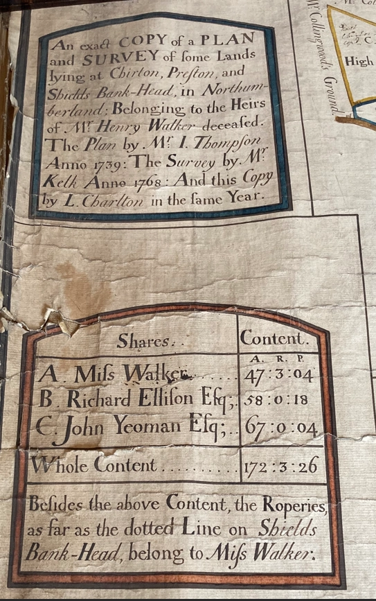
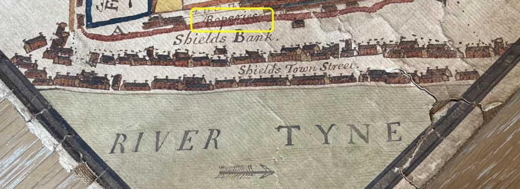
The document describes land which has been left to three people by the then deceased previous owner, Mr Henry Walker. Two men and one woman are the recipients: Miss Walker, Richard Ellison Esq and John Yeoman Esq, with each piece of allotted land highlighted as A, B or C depending on the recipient, with Miss Walker also being the beneficiary of a ropery in Shields on what is today Yeoman Street (John Yeoman’s inherited land (C) behing not far behind this).
Each piece of land is measured in acres, roods and poles. A.R.P. These are ancient units, initially defined for example by how much land could be ploughed in one day by oxen, but by this time more accurate values were used.

This plan was actually created in 1739 and then a survey, presumably of the specific size of the fields was then conducted at the time of this document, almost 30 years later in 1768.
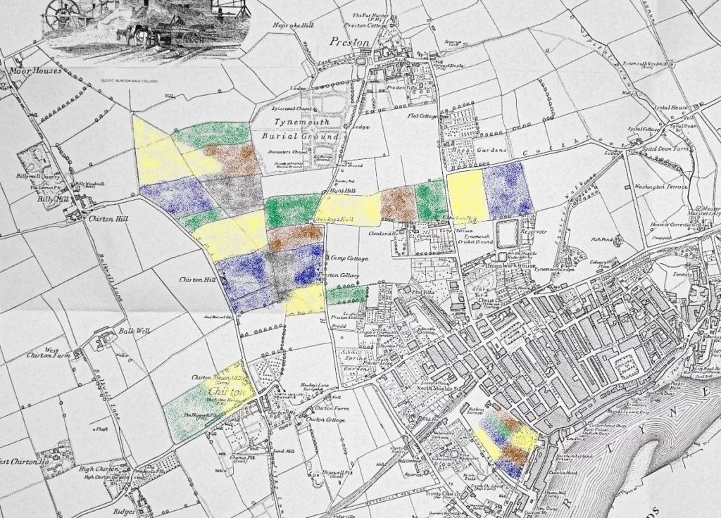
By matching field boundaries and street names to a later ordnance survey map, it is possible to get a surprisingly accurate picture of which pieces of land and which roads are being shown.
The large plan is approximately 75cm x 60cm, on paper, coloured by hand and bonded to fabric. It is divided into three main segments. The first, shown below, starts from Cut Throat Lane, a long road extending from Preston to Tynemouth which today includes Preston Avenue and King Edward Road.
If you look closely, below Preston Road two buildings are shown near what is today Camp Terrace. Could these be army billets? Also shown are tiny details such as the position of gates within field boundaries, yet Christ Church, the main building and focus of the area is not featured.
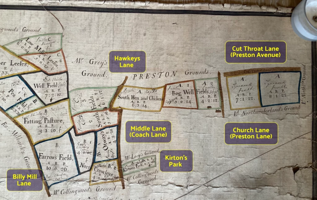
Coach lane, continuing with the strange chicane onto Hawkey’s lane is visible including at that juncture an image of Hawkey’s Hall, one of the local mansions that also features on the 1856 map below.
Estates outside of the land highlighted belong to:
- Mr Collingwood — Edward Collingwood (1743-1809), barrister, landowner and cousin of Cuthbert Collingwood later of Trafalgar fame. Edward also built Greenwich Hospital, Dissington Hall in Ponteland and the first dock where Smith’s Dock is today.
The nearby Chirton House was owned by James Hylton Lawson (below) and was sold to Collingwood, who passed it to his cousin Cuthbert Collingwood. In 1791 Cuthbert Collingwood married Sarah Blackett, daughter of John Blackett, the wealthy coal baron, who also owned extensive land in the area. - Mr Grey — Charles Grey (1729-1807), 1st Earl Grey, Northumbrian nobility and distinguished commander in the Revolutionary War. Father of Earl Grey Prime Minister.
- Sir Ra Milbank — Ralph Milbanke (1725-1798), baronet and MP.
- Mr Hylton Lawson & Captain Lawson — James Hylton de Cardonnel Lawson owner of Chirton Hall, and relative?
- Earl of Carlisle — Frederick Howard (1748-1825), 5th Earl of Carlisle, Politician and guardian of Lord Byron.
- Lord Northumberland — Hugh Percy (1714-1786), 1st Duke of Northumberland, after the title had been restyled.
These men must have known North Shields was on the cusp of becoming a major East Coast town.
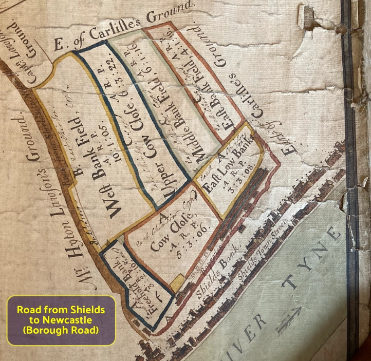
The second segment of the plan shows the riverside area ‘North Shields’. The road marked “road from Shields to Newcastle” is likely Borough Road which may likely have joined the turnpike at Coach Lane.
Looking more closely at the riverside, the detail on the tiny buildings is fantastic — difficult to know if the drawings show actual buildings of the time but the ropery (now Yeoman Street) are identified. In the slightly later Fryer Map of 1773 this is named as belonging to Matthew Waters Esq, who also owned a good amount of land behind this ropery on the bank top. This land must have only recently came into his ownership as it is divided between the three owners on this 1768 plan.
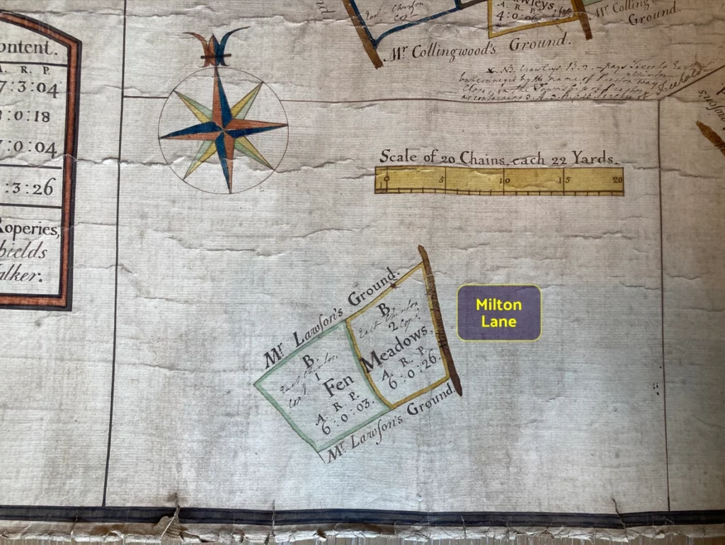
The third and smallest segment of the plan shows Milton Lane in East Chirton, which appears to line up with the modern Billy Mill Lane, as an isolated southern section of that road. Above it is the scale of the plan: 20 chains, each 22 yards.
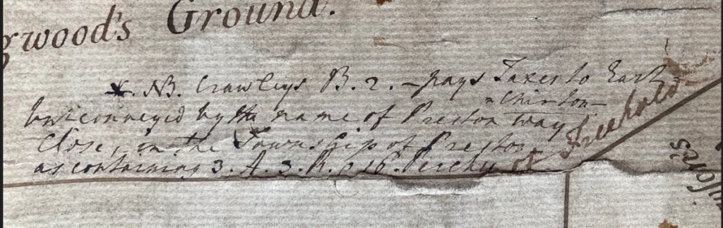
There is also some text in the corner, which we’ve yet to be able to read but appears to mention taxes.
If anyone has any further information to add, or questions, please do contact Penbal.
Never miss an article. Enter your email or give our FB page a like


No air-built castles, and no fairy bowers,
But thou, fair Tynemouth, and thy well-known towers,
Now bid th’ historic muse explore the maze
Of long past years, and tales of other days.
Pride of Northumbria!—from thy crowded port,
Where Europe’s brave commercial sons resort,
Her boasted mines send forth their sable stores,
To buy the varied wealth of distant shores.
Here the tall lighthouse, bold in spiral height,
Glads with its welcome beam the seaman’s sight.
Here, too, the firm redoubt, the rampart’s length,
The death-fraught cannon, and the bastion’s strength,
Hang frowning o’er the briny deep below,
To guard the coast against th’ invading foe.
Here health salubrious spreads her balmy wings,
And woos the sufferer to her saline springs;
And, here the antiquarian strays around
The ruin’d abbey, and its sacred ground.
Jane Harvey
From ‘The Castle of Tynemouth. A Tale’ (1806)
Photograph: Lee Stoneman
Photograph: Lee Stoneman
No air-built castles, and no fairy bowers,
But thou, fair Tynemouth, and thy well-known towers,
Now bid th’ historic muse explore the maze
Of long past years, and tales of other days.
Pride of Northumbria!—from thy crowded port,
Where Europe’s brave commercial sons resort,
Her boasted mines send forth their sable stores,
To buy the varied wealth of distant shores.
Here the tall lighthouse, bold in spiral height,
Glads with its welcome beam the seaman’s sight.
Here, too, the firm redoubt, the rampart’s length,
The death-fraught cannon, and the bastion’s strength,
Hang frowning o’er the briny deep below,
To guard the coast against th’ invading foe.
Here health salubrious spreads her balmy wings,
And woos the sufferer to her saline springs;
And, here the antiquarian strays around
The ruin’d abbey, and its sacred ground.
Jane Harvey
From ‘The Castle of Tynemouth. A Tale’ (1806)